


- Technology
- Geospatial Solutions Market
Geospatial Solutions Market Size, Share, and Growth Forecast 2026 - 2033
Geospatial Solutions Market by Component (Hardware, Software, Services), by Deployment Mode (On-Premise, Cloud-Based), by Technology (Geospatial Analytics, Remote Sensing, GPS, 3D Scanning), End-user (Utilities, Business, Transportation, Defense & Intelligence, Infrastructural Development, Natural Resource, Others), and Regional Analysis, 2026 - 2033
Geospatial Solutions Market Size and Trend Analysis
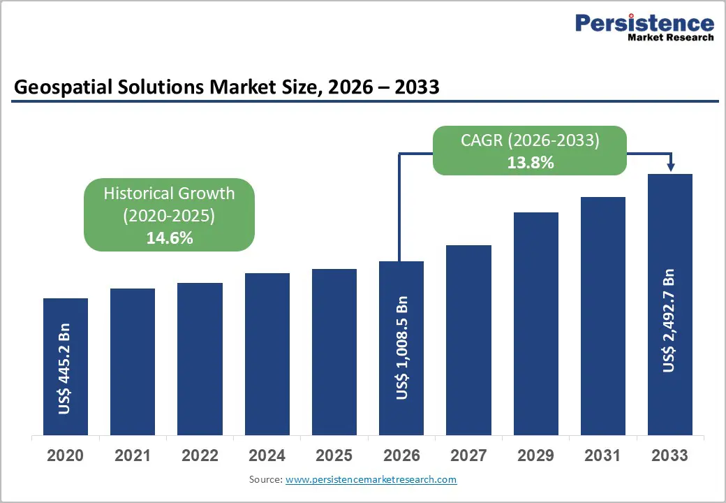
The global geospatial solutions market size is expected to be valued at US$ 1,008.5 billion in 2026. Geospatial solutions are experiencing rapid growth as they integrate advanced technologies such as AI, IoT, and big data to enable precise decision-making across various sectors.
These solutions support urban planning, disaster management, and environmental monitoring with real-time insights. Government programs such as NASA’s Earth observation initiatives and the EU’s Copernicus program provide high-quality spatial data, while the expansion of smart city projects worldwide drives demand for analytics platforms. Applications in agriculture, logistics, and infrastructure further enhance operational efficiency and sustainability.
Key Industry Highlights:
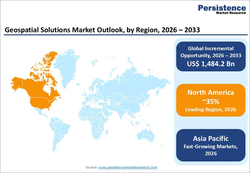
- Leading Region: North America leads the Geospatial Solutions market with a 35% share in 2025, driven by NASA and USGS data ecosystems.
- Fastest-Growing Region: Asia Pacific is the fastest-growing region at 16% CAGR between 2025 and 2032, fueled by urbanization in India and China.
- Leading Component Category: Software dominates the component segment with a 45% share in 2025, offering versatile GIS and analytics capabilities.
- Fastest-Growing Technology Category: Remote Sensing is the fastest-growing technology, supporting climate monitoring and environmental applications at a 15% CAGR.
- Key Opportunity: Expansion in Defense & Intelligence presents a major opportunity, with geospatial investments growing approximately 10% annually.
| Key Insights | Details |
|---|---|
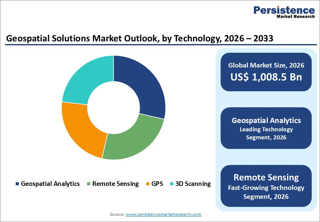
| Geospatial Solutions Size (2026E) | US$ 1,008.5 billion |
| Market Value Forecast (2033F) | US$ 2,492.7 billion |
| Projected Growth CAGR (2026 - 2033) | 13.8% |
| Historical Market Growth (2020 - 2025) | 14.6% |
Market Dynamics
Drivers - Integration of Artificial Intelligence and Cloud Platforms Enhancing Large-Scale Geospatial Data Processing
Advancements in artificial intelligence and cloud computing are significantly strengthening geospatial capabilities by enabling efficient processing and analysis of large spatial datasets. AI-based algorithms help automate image interpretation, pattern detection, and predictive modeling, improving the accuracy and speed of geospatial analytics. These technologies allow organizations to extract meaningful insights from satellite imagery, aerial data, and sensor networks for applications such as environmental monitoring and disaster response.
Cloud platforms further support scalability by providing high-performance computing resources for storing and processing extensive geospatial information. Agencies such as the National Aeronautics and Space Administration and the United States Geological Survey utilize advanced analytics and cloud infrastructure to manage large earth observation datasets. As industries adopt real-time geospatial intelligence for logistics, utilities, and mobility planning, demand for integrated AI-driven geospatial solutions continues to grow.
Rising Government Infrastructure and Smart City Investments Increasing Demand for Geospatial Technologies
Large-scale public infrastructure programs are accelerating the adoption of geospatial solutions for planning, monitoring, and asset management. Governments increasingly rely on geographic information systems, satellite imagery, and spatial analytics to support transportation development, urban expansion, and environmental assessments. These tools help authorities improve project planning accuracy, monitor construction progress, and optimize land-use decisions across major infrastructure initiatives.
Programs such as the Infrastructure Investment and Jobs Act in the United States and the Smart Cities Mission in India demonstrate growing reliance on geospatial technologies. Government agencies, including the Federal Highway Administration and the National Remote Sensing Centre, employ GIS mapping, remote sensing, and GPS-based systems to enhance planning efficiency, infrastructure management, and sustainable urban development.
Restraints - High Costs and Technical Challenges in Integrating Geospatial Data with Existing Systems
The adoption of geospatial solutions is often constrained by the high costs associated with integrating spatial data into existing IT and enterprise systems. Organizations face significant expenses in adapting legacy infrastructure, configuring software, and ensuring data compatibility, which can consume a substantial portion of project budgets. This financial barrier particularly affects small and medium-sized enterprises seeking to leverage advanced geospatial analytics.
In addition, a shortage of skilled professionals capable of handling complex geospatial datasets further limits adoption. Firms struggle to implement AI-driven analytics, 3D mapping, and real-time monitoring without specialized expertise. This combination of financial and technical challenges slows market penetration and delays deployment of innovative geospatial technologies across diverse industries globally.
Regulatory Restrictions and Privacy Concerns Limiting Geospatial Data Utilization
Stringent regulations and privacy laws present significant hurdles to geospatial data sharing and utilization. Policies such as the EU’s GDPR, along with national security restrictions, require firms to implement strict data governance practices, which can be costly and time-consuming. Compliance challenges are amplified when organizations operate across multiple regions with varying standards.
These regulatory and privacy constraints reduce the efficiency of cross-border geospatial projects and can discourage collaboration among enterprises and government agencies. Companies must navigate fragmented legal frameworks while ensuring secure data handling, which limits large-scale deployment of geospatial technologies for applications like urban planning, environmental monitoring, and logistics optimization.
Opportunity - Expanding Opportunities in Remote Sensing and Climate Monitoring for Geospatial Applications
The growing focus on climate monitoring and environmental management is creating strong opportunities for geospatial solutions, particularly in remote sensing technologies. Satellite-based observation systems enable real-time monitoring of natural disasters, deforestation, and changing weather patterns, supporting rapid response and strategic planning. Large datasets from programs like the Copernicus Programme are processed daily to provide actionable insights for flood management, wildfire tracking, and environmental conservation.
Global initiatives to meet climate targets are driving substantial investments in remote sensing services for natural resource management, renewable energy planning, and urban sustainability projects. Companies offering advanced analytics, high-resolution imagery, and cloud-enabled processing can tap into rising demand across regions such as the Asia Pacific, where climate monitoring and disaster preparedness are high priorities.
Growth Potential in Defense and Precision Agriculture Applications
Defense and agriculture represent significant growth avenues for geospatial technologies. Military and intelligence agencies increasingly rely on geospatial data for mission planning, surveillance, and precision targeting, enhancing operational accuracy and reducing risks. Agencies such as the National Geospatial-Intelligence Agency leverage advanced geospatial analytics to improve strategic decision-making and situational awareness, resulting in consistently increasing government contracts.
In agriculture, precision farming and satellite-based monitoring are improving crop yields and resource management. Technologies that track soil health, irrigation patterns, and weather impacts allow farmers to optimize inputs and boost productivity, aligning with rising demand for sustainable practices. Companies focusing on these end-use sectors can capture high-value opportunities in both developed and emerging markets.
Category-wise Analysis
Component Insights
Software is the leading component in the geospatial solutions market, holding 45% of the 2025 share. GIS platforms and advanced analytics tools dominate due to their integration with AI and cloud technologies, offering scalable and efficient data processing. Platforms like Esri power a majority of U.S. federal projects, providing cost-effective visualization, mapping, and decision-support solutions compared to hardware-centric approaches.
Services, including consulting, integration, and support, are emerging as the fastest-growing segment. Organizations increasingly require expert assistance to implement AI-driven analytics, remote sensing workflows, and 3D mapping. As enterprises adopt geospatial intelligence for real-time decision-making, service offerings that simplify deployment and maintenance are seeing strong demand across sectors such as utilities, logistics, and environmental management.
Deployment Mode Insights
Cloud-based deployment leads the market with a 52% share in 2025, driven by flexibility and scalability for large geospatial datasets. Enterprises and government agencies leverage cloud platforms to store, process, and analyze high-resolution satellite imagery and sensor data. Initiatives like NASA Earthdata provide cloud solutions that reduce costs and enable remote access, making them ideal for applications in utilities, transportation, and research.
On-premise solutions are the fastest-growing deployment mode, favored by organizations requiring enhanced data security, regulatory compliance, and control over sensitive spatial datasets. Sectors such as defense, critical infrastructure, and energy increasingly adopt hybrid approaches that combine on-premise and cloud systems for secure, high-performance geospatial analytics.
Technology Insights
Geospatial analytics leads technology adoption with a 38% share in 2025, thanks to its ability to detect patterns and trends in urban planning, disaster response, and environmental monitoring. AI enhancements provide significantly improved insights compared to traditional GPS or mapping tools, enabling smarter decision-making in projects across government and enterprise sectors. Remote sensing is the fastest-growing technology, offering high-resolution satellite imagery and LiDAR data for climate monitoring, precision agriculture, and infrastructure planning. Its ability to deliver timely, actionable intelligence on environmental and operational conditions is driving adoption across both public and private sectors.
End-user Analysis
Defense & intelligence leads end-user adoption with a 28% share in 2025. Agencies such as the National Geospatial-Intelligence Agency utilize geospatial platforms for surveillance, reconnaissance, and mission planning, enabling operations with sub-meter accuracy and rapid situational awareness. Agriculture and smart city planning are among the fastest-growing end-use sectors. Precision agriculture leverages satellite imagery and spatial analytics to optimize yields and resource usage, while urban planners use geospatial tools for sustainable infrastructure development, traffic management, and disaster preparedness, driving strong demand in emerging markets.
Regional Insights
North America Geospatial Solutions Market Trends and Insights
North America leads the geospatial solutions market with a 35% share in 2025, driven by strong U.S. leadership and extensive government initiatives. Agencies such as NASA and United States Geological Survey provide open-access datasets supporting FEMA disaster response and environmental monitoring. Regulations from the Federal Aviation Administration have boosted drone mapping adoption, with over 1.5 million units in operation, fostering innovation in Silicon Valley and other tech hubs.
The region’s focus on smart infrastructure, transportation, and defense applications continues to drive demand for integrated AI and cloud-based geospatial analytics. Enterprises and government agencies increasingly deploy advanced GIS, remote sensing, and analytics platforms for urban planning, precision agriculture, and emergency management, ensuring North America maintains its leadership position in global geospatial solutions.
Europe Geospatial Solutions Market Trends and Insights
Europe accounts for a significant portion of the global geospatial solutions market, with a projected CAGR of 12.5% from 2025 to 2032. The Copernicus Programme harmonizes Earth observation data across the continent, supporting Germany’s precision agriculture and renewable energy projects in Spain. The U.K. and France leverage geospatial intelligence for defense and infrastructure planning, ensuring accurate mapping and efficient resource management.
The region is also emphasizing standardization and interoperability across GIS, remote sensing, and satellite platforms. Public-private collaborations and EU-funded initiatives are promoting urban smart city development, environmental monitoring, and transportation optimization. These trends are driving the adoption of advanced geospatial analytics and cloud-based solutions across both government and commercial sectors in Europe.
Asia Pacific Geospatial Solutions Market Trends and Insights
Asia Pacific is the fastest-growing region, with geospatial solutions expanding at a 16% CAGR between 2025 and 2032. China’s BeiDou Navigation Satellite System and India’s RISAT programs support smart city projects, precision agriculture, and disaster management. Japan and ASEAN countries utilize advanced remote sensing for monitoring natural hazards, urban expansion, and industrial development.
Rapid urbanization, government investment in infrastructure, and increasing adoption of AI and cloud-enabled geospatial analytics are driving market growth. Industries such as logistics, utilities, and manufacturing increasingly rely on real-time spatial data to optimize operations, enhance efficiency, and support sustainable development initiatives across Asia Pacific.
Competitive Landscape
The geospatial solutions market is moderately consolidated, with leading firms focusing on innovation and strategic growth. Key strategies include investing in AI-driven analytics, expanding cloud capabilities, and acquiring high-quality geospatial datasets. Companies are emphasizing scalable software and services to differentiate themselves in a competitive environment, offering solutions that streamline mapping, remote sensing, and analytics across various industries.
Emerging trends show a shift toward hybrid deployment models, particularly among small and medium enterprises seeking flexibility, cost-efficiency, and secure data management. Innovation in SaaS platforms and integrated services is helping providers meet growing demand for real-time insights, precision decision-making, and industry-specific geospatial applications.
Key Developments:
- In June 2025, NASA awarded a contract to a leading satellite provider for hyperspectral satellites, enhancing environmental monitoring, disaster response, and climate analysis with higher-resolution data and improved spectral imaging capabilities.
- In April 2025, a major GIS platform released an AI-enhanced version of its software, enabling real-time spatial analytics, predictive modeling, and advanced visualization for urban planning, agriculture, and infrastructure management.
- In November 2024, a geospatial technology firm acquired a LiDAR specialist, strengthening its 3D scanning, mapping, and surveying capabilities to support smart city projects, autonomous systems, and precision engineering applications globally.
Companies Covered in Geospatial Solutions Market
- Esri
- Trimble Inc.
- Hexagon AB
- Bentley Systems, Incorporated
- Autodesk, Inc.
- Garmin Ltd.
- Topcon Corporation
- Maxar Technologies Inc.
- TomTom N.V.
- HERE Technologies
- Pitney Bowes Inc.
- SuperMap Software Co., Ltd.
- Fugro N.V.
- Vexcel Imaging GmbH
- Intermap Technologies Corp.
Frequently Asked Questions
The market is expected to reach US$ 1,008.5 billion, driven by software (45% share) and cloud-based solutions (52% share).
Demand is fueled by AI integration and government infrastructure investments such as IIJA.
North America leads with a 35% share in 2025, supported by NASA and USGS data initiatives.
Remote sensing is a major opportunity, growing rapidly for climate and environmental applications.
The market is moderately consolidated, with top firms focusing on AI, cloud SaaS, and hybrid deployment models.


